
A complete guide to the Brean Down Way walk, with bus return and cycling options
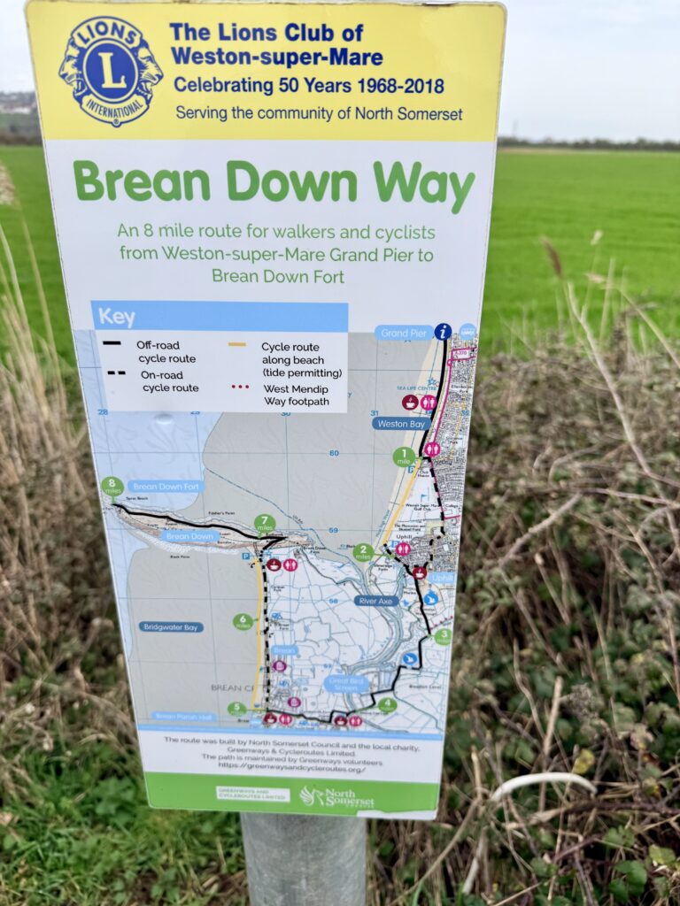
The Brean Down Way is one of the more accessible and enjoyable coastal walks in Somerset, linking Weston-super-Mare with the distinctive limestone headland of Brean Down. At around 8 miles long, the Brean Down Way follows a largely flat, purpose-built path that provides a continuous route across the River Axe, connecting North Somerset with the wider Somerset coastline.
What makes the Brean Down Way particularly appealing is its variety. Within a relatively short distance, the route moves from the traditional and often busy seaside setting of Weston-super-Mare to quiet estuary landscapes, before finishing at one of the most recognisable natural landmarks in the region.
The Brean Down Way is suited to walkers and cyclists, and with bus connections linking Brean, Burnham-on-Sea and Weston-super-Mare, it is easy to plan as a one-way walk.
Brean Down Way Route & Map
The Brean Down Way runs for approximately 8 miles from Weston-super-Mare seafront to Brean Down Fort. The route is mostly flat, well surfaced and easy to follow, making it suitable for a wide range of abilities. From the fort, it is a further 2 miles back to Brean village for bus stops, while walking the full return to Weston creates a 16-mile day. For this reason, most people choose to use the bus for one leg of the journey.
Unlike more rugged coastal paths, the Brean Down Way is designed for accessibility. It forms part of National Cycle Network 33, which explains the quality of the surface and its popularity with cyclists, but it is also a relaxed walking route.
For most people, the Brean Down Way takes between three and four hours to walk one way, depending on walking speed and (in our case at least) the number of cafe stops.
Disclosure: Some of the outbound links on this page are affiliate links to sites that we use and would genuinely recommend. Using them doesn’t cost you extra, but it does help support this free guide. We also provide links to other sites that we believe may be helpful to you.
1: Weston to Uphill on the Brean Down Way (2 miles)
The Brean Down Way typically begins on the seafront in Weston-super-Mare, near the Grand Pier. From here, the route heads south along the promenade, following the curve of Weston Bay.
This section of the Brean Down Way between Weston-super-Mare and Uphill offers a gradual transition from town to estuary, with a choice of routes depending on conditions. At low tide, it is possible to walk along the beach from Weston, following the wide expanse of sand towards Uphill. This route passes through beach car park areas at both Weston and Uphill, so care is needed around vehicles, and also passes close to a designated kite surfing zone, which should be avoided when in use.
This can be an enjoyable and more open-feeling option, but it is important to check tide times carefully, as the incoming tide can move very quickly across the Bristol Channel.
If the tide is not suitable, the alternative is to follow the road and the signed route inland via Uphill Road.
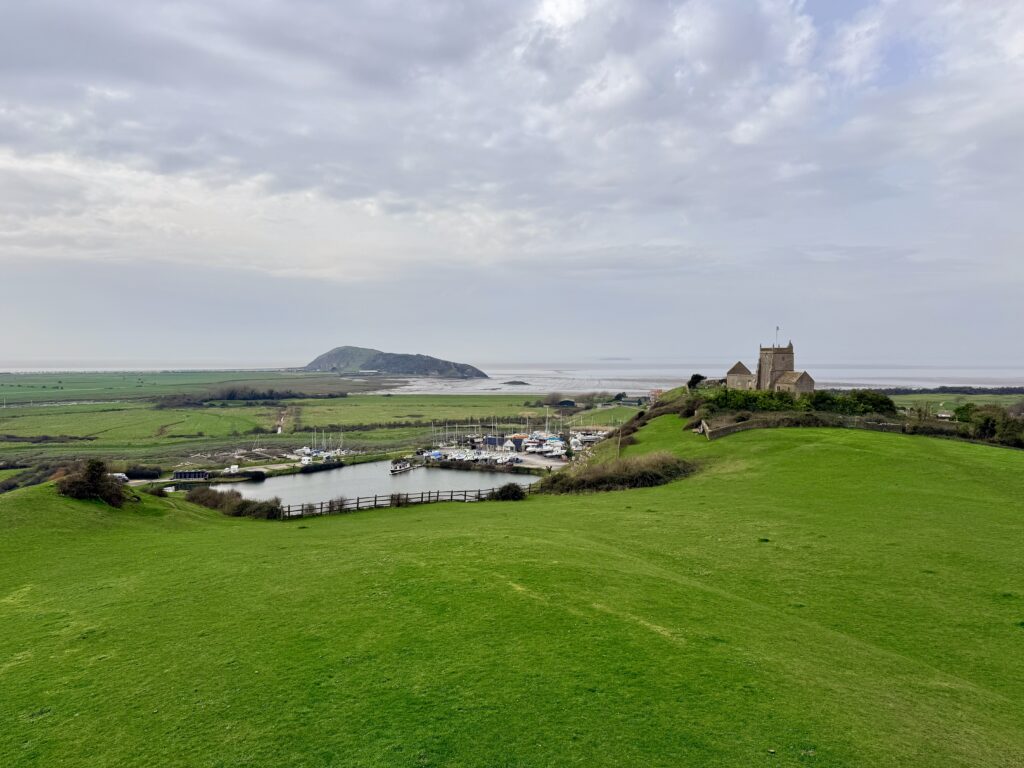
Whichever option you choose, the route converges at Uphill, passing the marina and the mouth of the River Axe. It is a natural pause on the Brean Down Way, with St Nicholas Church on the hill, and estuary views marking the transition into a more open, wildlife-rich landscape.
There are several convenient places to stop, including the Boat House Café by the marina, which we would particularly recommend. It is busy, welcoming, walker and dog-friendly. There are also a number of other pubs and cafés in the village, and all looked worthy of a visit before continuing the walk into the quieter estuary section.
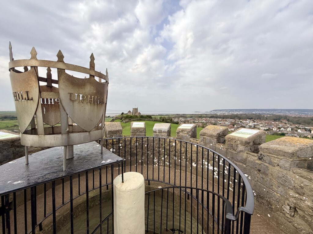
Worth a Short Detour: Uphill Village, Church and Beacon
If you have time, Uphill is well worth a short detour from the Brean Down Way. Walking into the village gives you the option of heading up to St Nicholas’ Church, perched above the estuary, and continuing on towards the beacon for wider views across Weston Bay, the River Axe and the surrounding Levels.
It makes a pleasant variation on the direct route, especially if you prefer a little more interest and elevation early on. By following a broadly clockwise route through the Uphill Nature Reserve, visiting the church and beacon it is then possible to return to the Brean Down Way just beyond the marina and continue south towards the River Axe crossing. This variation can also be used as a shorter return walk from Weston-super-Mare.
2: Crossing the River Axe at Brean Cross Sluices (4 miles)
Shortly after passing the marina at Uphill, the Brean Down Way enters Walborough Nature Reserve, an area of salt marsh and grassland managed by the Avon Wildlife Trust.
This section of the route feels noticeably quieter, with the landscape opening out into a mix of tidal creeks, grazing land and wetland habitat. It is a good place to slow the pace slightly, particularly for birdwatching, with species such as redshank, shelduck, and other waders often seen along the estuary.
The path remains clear and easy to follow, passing through several gates along the way. There are some variations that allow you to walk closer to the banks of the River Axe, but tempting as it may seem, it is important not to attempt to cross the river (or enter the water) this way. The estuary here contains deep, soft mud, which can be extremely dangerous. It really is not safe to attempt crossing away from the designated path at Brean Cross Sluices.
Brean Cross Sluices
The footpath across the River Axe at Brean Cross Sluices is a relatively recent addition to the route, making the journey possible as a continuous coastal link, avoiding what was once a much longer inland diversion. For both walkers and cyclists, it provides a clear, direct route onward to Brean.
The crossing itself is straightforward, with a well-maintained path leading across, but it is the surrounding landscape that makes this section particularly memorable. This is a tidal estuary, shaped by the flow of the River Axe and the powerful tides of the Bristol Channel, creating wide, open views across the Somerset Levels and a strong sense of space.
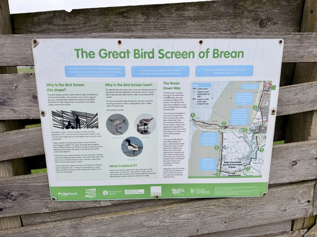
This stretch is also important for wildlife. The estuary and surrounding wetlands support a range of bird species, particularly waders and wildfowl that feed on the exposed mud at low tide. Along the route, you will pass the Great Bird Screen of Brean, a purpose-built driftwood structure designed to allow close-up views of birds without disturbing them. It provides some shelter from the wind and creates a natural place to pause.
3: Across the Levels towards Brean Village (5 miles)
After crossing the River Axe, it is possible to follow a footpath alongside the River Axe towards Brean Down, running close to the estuary. However, this route is only open between 16th May and 18th July to protect sensitive birdlife; outside of these dates, you will need to follow the signed inland alternative.
There is a noticeable change in the atmosphere here. After the open estuary and quieter sections, the route runs alongside Diamond Park Holiday Park. Out of season, it can feel almost eerily deserted, with long rows of static caravans and barely a hint of life. In high summer, however, the contrast is striking, as the same area becomes one of the busier and rather more crowded stretches of the coast. It is, nevertheless, interesting.
Here’s a tighter, cleaner version with a light touch of tone:
When we walked through this section, we were fascinated by the small, standalone buildings beside many of the caravans. We later discovered these are individual service pods, each with a private toilet, basin, shower and storage space. A rather more deluxe take on caravanning.
During the main season, signposts direct visitors to on-site cafés and facilities, many of which are open to non-residents.
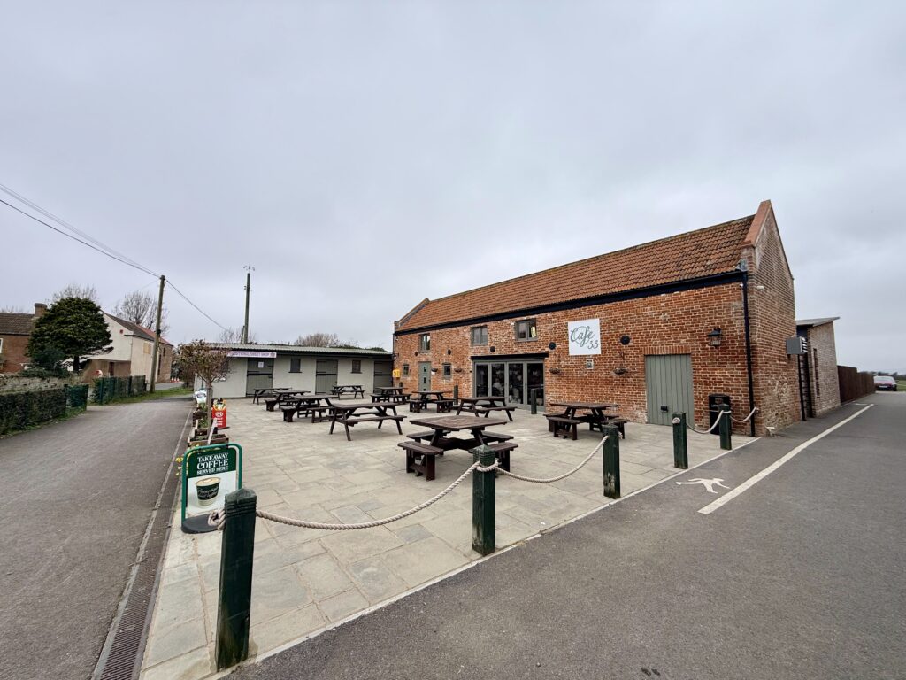
The route then emerges from the caravan parks onto Weston Road, where Café 33, with its parking, makes another appealing stopping point. This is also where you will find Brean Bike Hire, a useful option for those considering cycling instead of walking the full route.
From here, it is a short and straightforward walk along a footpath beside the road into Brean village, where the route begins to take on more of the character of a traditional seaside resort. In the main season, Brean offers much of what you would expect, with cafés, takeaways, amusements and holiday facilities serving visitors staying along this stretch of coast.
We visited in winter, when much of it felt quiet, with only limited places open and a very different atmosphere from the summer months. That contrast is quite striking and gives a sense of just how seasonal this part of the coast can be.
4: Brean village to Brean Down (7 miles)
From Weston Road, you will see the village hall straight ahead. It is possible to cross the road here, taking care as it can be busy, particularly in the main season, and follow a narrow footpath down to Brean beach.
If the tide permits, you can then turn right and walk along the beach towards Brean Down, which becomes clearly visible in the distance. This can be an enjoyable and more direct option, but it is important to be aware of conditions. It is generally only safe to paddle or swim close to high tide. At low tide, the sea retreats a considerable distance, exposing vast areas of sand and the soft mud typical of the Bristol Channel.
At the base of Brean Down, you will find the Brean Down National Trust visitor centre, along with a café, car park and toilets, making it a natural place to pause before the final stage of the walk.
5: Finishing the Brean Down Way (8 miles)

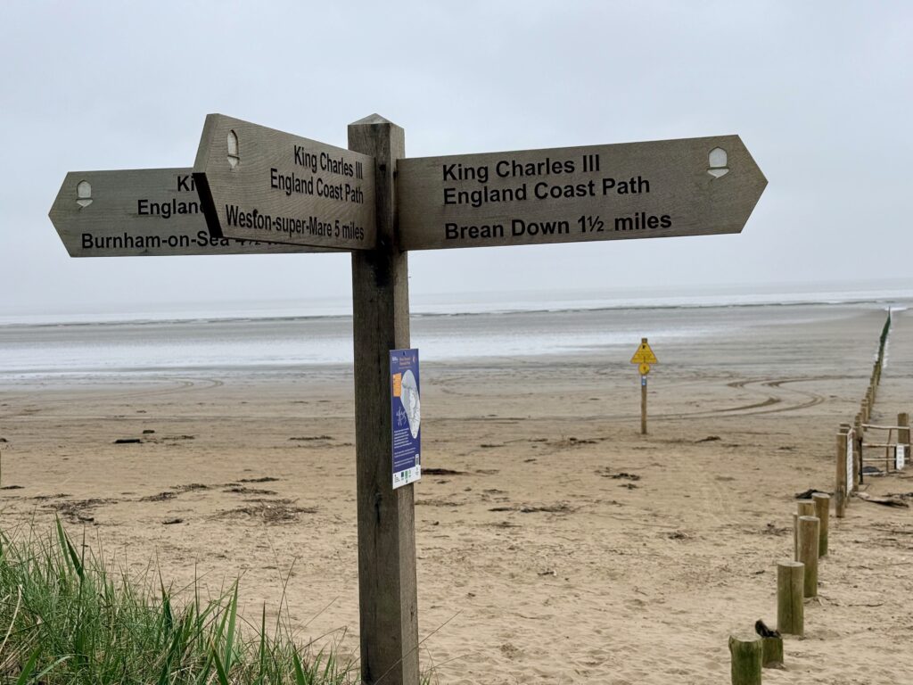
To continue, you can either take the steps up onto the headland or, for a slightly easier and more gradual ascent, follow the old military road that leads off to the right ahead of you. Both routes take you onto Brean Down itself, from where the path continues along the ridge to Brean Down Fort at the far end, bringing the total distance from Weston-super-Mare to around eight miles.
Brean Down is one of the most distinctive natural features on this stretch of coastline. Formed from limestone and rising to just under 100 metres, it extends for around a mile and a half into the Bristol Channel, creating a dramatic contrast to the otherwise flat surrounding landscape. Its position has made it strategically important for centuries. The fort at the tip was built in the 1860s as part of a chain of coastal defences designed to protect against a potential French invasion, and it was later reused during the Second World War.
THere is a tidied and corrected version with smoother flow:
Along with Steep Holm and Flat Holm, it is a natural extension of the Mendip Hills. Today, the headland offers wide, uninterrupted views across the Bristol Channel, with both islands clearly visible offshore and, on clear days, the coastline of South Wales beyond. It is also an important site for wildlife, where a mix of grassland and coastal habitats supports a variety of plant and bird species.
We have written a more detailed guide to walking on the Brean Down walk itself, which you can read here.
Continue Exploring This Stretch of Coast
If you are planning to extend the walk or explore more of the area, you may also find our other guides useful. For a closer look at the headland itself, including the fort, views and route options, see our guide to Walking Brean Down.
If you are starting or finishing in Weston, our Weston-super-Mare visitor guide includes ideas for things to do, places to eat and practical tips for your visit.
If you are thinking of continuing towards Burnham-on-Sea, or returning another day to explore more of this part of the Somerset coast, our Burnham-on-Sea visitor guide includes practical information, ideas for things to do and more local background.
Returning by bus from the Brean Down Way (First Bus 20 & 20A)
One advantage of walking the Brean Down Way is the option to return to Weston-super-Mare by bus rather than retracing your steps.
The nearest bus stops are in Brean village along Weston Road, around a 10 to 15 minute walk from the National Trust car park at the base of Brean Down. From the visitor centre, simply retrace your steps towards Brean village.
The main service is usually the First Bus 20 or 20A, running between Burnham-on-Sea and Weston-super-Mare via Brean, providing a straightforward return to your starting point.
Services tend to be more frequent during the main season, but it is still worth checking times in advance, particularly later in the day or outside summer months. With a little planning, the Brean Down Way becomes an easy and practical one-way walk.
Cycling the Brean Down Way
The Brean Down Way is also one of the best easy cycle routes in Somerset. Its flat profile, good surface and largely traffic-free nature make it ideal for a wide range of cyclists.
Cycling the Brean Down Way from Weston-super-Mare to Brean Down typically takes around an hour (one way), though many choose to take longer to enjoy the surroundings.
There are a small number of sections where cyclists may need to dismount, particularly near Brean Down, but these are limited. The route is a shared path used by walkers, families and dog walkers, and there are a few gates along the way.
Overall, the Brean Down Way offers a safe and enjoyable ride for both casual and more regular cyclists, including families with children.
Bike hire is available at several points along or close to the route. Brean Bike Hire on Weston Road is the most convenient option, as it is located on the route itself. In Weston-super-Mare, seasonal hires are sometimes available along the seafront, particularly near the Grand Pier, though availability can vary.
In Burnham-on-Sea, cycle hire is available at The Bicycle Shack, which offers another option close to the route. Some of the holiday parks also offer cycle hire.
As availability and opening times can change, particularly outside the main season, it is worth checking ahead before setting out. For many, hiring a bike in Brean and cycling a shorter section of the route, or riding one way and returning by bus, offers a flexible and enjoyable way to experience the Brean Down Way.
Shorter Brean Down Way options

While the full Brean Down Way makes for a satisfying day out, it can easily be adapted into shorter sections and variants depending on time, conditions and preference.
Weston-super-Mare to Uphill Walk
A popular option is to walk from Weston-super-Mare to Uphill and back, taking in the church and beacon above the village before stopping at a pub or café and returning the same way. It offers a manageable distance with a good mix of seafront, estuary and elevated views. We would really recommend this as a contrast to the busier feel of Weston. With a short climb up to the church above Uphill, the views are excellent and, on a clear day, you can even spot Glastonbury Tor.
Brean Down Walk
If you do nothing else, this is the walk to do. It really is spectacular.
Brean Down is also well worth walking in its own right, with the climb to the fort and the views across the Bristol Channel making it a particularly rewarding outing. We have covered this in more detail in our dedicated guide, which you can read here.
Brean Cross Sluice Walk
For something slightly longer, it is possible to walk between Brean and the Brean Cross Sluices and return, or from Uphill to the sluices and back. Both options offer a strong sense of scale, landscape, and wildlife without requiring a walk of the full route.
The availability of bus services makes it easy to adapt any of the walks, either by starting at one end and returning from the other, or by linking sections together in different ways.
The route can also be extended by joining the King Charles III England Coast Path towards Burnham-on-Sea. From Brean village, you can turn left and, if the tide permits, follow the beach in that direction, creating a longer and more varied coastal walk with Brean Down behind you and the wide expanse of Bridgwater Bay opening out ahead.
The bus route connects Burnham-on-Sea and Weston-super-Mare, making this a practical one-way option. For a little added interest, it is also possible to walk on from Burnham to nearby Highbridge and return by train, offering an alternative to the bus and adding a different element to the day.
There are plenty of variations, but a small note of caution is worth keeping in mind. Brean can become very busy in the main season, with parking often limited, while parking at Uphill, particularly near the beach, is affected by the tides. Checking conditions in advance or arriving early can make a noticeable difference to the overall experience.
What makes the Brean Down Way special
Two clear highlights are the views from Brean Down and from the church at St Nicholas above Uphill, both of which offer wide views across the Bristol Channel and inland across the Somerset Levels.
What makes the Brean Down Way particularly appealing is its flexibility. It can be walked in full, explored in shorter sections or linked with other routes such as the King Charles III England Coast Path. With bus and rail connections available, with a little imagination it is easy to plan without retracing your steps.
Above all, it is the sense of space that stands out, with wide skies, open views and a steady coastal backdrop that make the walk feel both easy and enjoyable.
Practical tips for walking the Brean Down Way
The Brean Down Way is generally straightforward and, for the most part, suitable for wheelchairs and pushchairs thanks to its flat, well-surfaced paths. The main exception is Brean Down itself, where the steps and uneven ground limit access. It is worth checking in advance before committing to the full route. The National Trust provides a detailed accessibility statement for Brean Down, available here.
Conditions along the route can vary. It is exposed in places, particularly across the estuary, and Brean Down itself can feel noticeably windier and cooler than the surrounding areas. Comfortable walking shoes are usually sufficient, and the route is easy to follow throughout.
There are no facilities on Brean Down itself, so it is worth bringing anything you may need. A picnic can be a good idea, especially as the views from the headland are exceptional and make it a natural place to stop.
Food, drink and toilets are available at Weston-super-Mare, Uphill and Brean, although there are longer, quieter stretches in between. As with much of the Bristol Channel coastline, it is also important to be aware of tidal conditions if you are considering any sections along the beach, as the tide can move quickly and expose areas of soft mud.
Final thoughts on the Brean Down Way
Walking the Brean Down Way from Weston-super-Mare is a great way to experience this part of the Somerset coast. It is not a particularly challenging route, but it offers a lot to see.
We love the views from Brean Down or the Beacon at Uphill, where you can look across the Bristol Channel towards South Wales, back along the coast to Weston-super-Mare, and south towards Burnham-on-Sea and, on clear days, Exmoor beyond. Wildlife enthusiasts and birdwatchers will also find plenty to enjoy along the estuary and Levels.
What makes the route particularly appealing is its variety. From the traditional seaside atmosphere of Weston to the quieter landscapes of the Levels, the history of Brean Down and the cafés and pubs along the way, it offers something for everyone and can be walked at any time of year.
The option to return by bus makes it especially practical, while its suitability for cycling adds further flexibility. Whether walked in full, explored in sections or cycled as a day ride, the Brean Down Way offers a great day out in the South West.
FAQs: Walking the Brean Down Way from Weston-super-Mare
How long is the Brean Down Way walk?
The Brean Down Way is around 8 miles from Weston-super-Mare seafront to Brean Down Fort, with most people taking between three and four hours one way depending on pace and stops. From the fort, the return to the bus stop in Brean village adds a further two miles. Walking the full route there and back makes for a long day of around 16 miles in total. For that reason, most people choose to use the bus for at least one direction, making the walk more manageable and allowing time to enjoy the route along the way.
Can you walk the Brean Down Way from Weston-super-Mare to Brean Down in one go?
Yes, the full Brean Down Way is a manageable day walk for most people. It is largely flat and easy to follow, with the main climb coming at the end if you continue up onto Brean Down itself. However, most people choose to take the bus for at least one leg of the journey rather than walk both ways, making the day more relaxed and allowing more time to enjoy the route.
Is the Brean Down Way easy?
For the most part, yes. The route is mostly flat, well surfaced and straightforward. It is much easier than many coastal walks, although Brean Down itself is steeper and less accessible, particularly if you take the steps rather than the old military road.
Can you walk from Weston-super-Mare to Uphill along the beach?
Yes, but only if the tide is suitable. At low tide it is possible to walk along the beach towards Uphill, although you need to take care around beach car parks, vehicles and the kite surfing area. If the tide is not right, the safer alternative is to follow the signed route inland via Uphill Road.
Is the Brean Down Way suitable for wheelchairs and pushchairs?
For the most part, yes. Much of the Brean Down Way follows flat, well-surfaced paths that should be suitable for wheelchairs and pushchairs. The main exception is Brean Down itself, where steps and uneven ground make access more difficult. It is worth checking the National Trust accessibility information before setting out.
Can you cycle the Brean Down Way?
Yes. The Brean Down Way also forms part of National Cycle Network 33 and is one of the easiest cycle routes in Somerset. It is mostly traffic free and well surfaced, although cyclists may need to slow down or dismount in a few places, particularly near Brean Down and at some gates.
Where can you hire bikes for the Brean Down Way?
Brean Bike Hire on Weston Road in Brean is one of the most convenient options, as it sits close to the route itself. In Burnham-on-Sea, cycle hire is available at The Bicycle Shack. Weston-super-Mare sometimes has seasonal hire options near the seafront, although availability can vary.
Can you return to Weston-super-Mare by bus?
Yes. One of the practical advantages of the Brean Down Way is that you can return by bus rather than walk back. The nearest stops are in Brean village along Weston Road, around 10 to 15 minutes on foot from the National Trust car park at the base of Brean Down.
Which bus returns from Brean to Weston-super-Mare?
The main return service is usually the First Bus 20 or 20A, which runs between Burnham-on-Sea and Weston-super-Mare via Brean. It is still worth checking current timetables in advance, especially outside the main holiday season.
Are there toilets and a café on the route?
Yes, but not everywhere. Food, drink and toilets are available in Weston-super-Mare, Uphill and Brean, and there is also a National Trust café, visitor centre and toilets at the base of Brean Down. There are no facilities on Brean Down itself.
Is there a shorter version of the Brean Down Way?
Yes. Shorter variations include walking from Weston-super-Mare to Uphill and back, walking from Uphill to the Brean Cross Sluices and returning, or simply walking Brean Down on its own. These all give a good sense of the area without committing to the full route.
What is the best time of year to walk the Brean Down Way?
The route can be enjoyed at any time of year, but the experience does vary. Summer brings longer days, more open cafés and busier holiday parks, while winter can feel much quieter and more atmospheric. In all seasons, it is worth checking tide times, weather and wind conditions before setting out.
Helpful Links
- Booking.com – for most accommodation needs. Look out for options that include free cancellation.
- Easy Tide – Free UK tidal prediction service, providing tidal data and tide times for the current day and 6 days into the future.
- Expedia – good for flights and packages.
- Get Your Guide – find and book things to see. Includes unusual things to do.
- Hostelworld – Hostel-focused booking platform that fosters backpack connections.
- MetOffice – Weather forecasts from the UK official meteorological office.
- National Express – UK-based coach operator providing long-distance bus services
- Omio – Book travel tickets by comparing trains, buses and planes in one search.
- Rental Cars – to search out and book hire cars.
- Rome2Rio – Great for comparing local transport options (and for locating bus stops).
- Ticketmaster – What’s On – Major Events – Venues – Bookings
- Trainline.com – our go-to online platform for booking train and bus tickets, offering route planning, price comparisons, seat reservations, and ticket sales.
- Traffic England – for live traffic updates on major roads.
- Traveline SW – Comprehensive public transport information from A to B by bus, coach, train, ferry in South West England and Great Britain.
- TripAdvisor – for reviews of… pretty much everything. Our go-to before booking anything.
- Vrbo – Great for self-catering and vacation holiday home rentals.
Over to you … have you recently travelled to South West England? What worked for you? What advice would you give to others? Please leave your comments below or join in the discussion in our Facebook Group.
New to South West England or returning after a while? Start with our ‘Travel Basics’ – quick guides packed with tips to help you plan your trip.
