
Somerset Walks – Hike to Wayford Woods
If you are looking for a quieter walk in South Somerset, this circular route from Winsham to Wayford Woods offers a varied and rewarding loop through gently rolling countryside, woodland and quiet lanes, with views stretching into Dorset and a number of interesting features along the way.
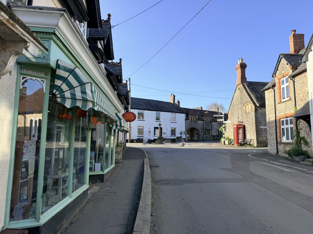
Winsham, Somerset
Starting in the pretty village of Winsham, with its traditional pub, The Bell Inn and community-run shop, the route heads out along the Chalkway, skirting the edge of the Cricket St Thomas Estate, best known as the filming location for the classic BBC comedy To the Manor Born. From here, it climbs steadily towards higher ground near Windwhistle, where the landscape opens up with wide views across the Somerset countryside and south into Dorset.
The return leg brings a clear change in character, descending towards the attractive village of Wayford, home to the church of St Michael and All Angels and the nearby Wayford Manor, a striking Tudor manor house dating from the 16th century, before joining a section of the Liberty Trail. A highlight of the walk is the stretch past Wayford Woods, which, in spring, is particularly appealing with bluebells and wildflowers and offers a peaceful spot for a picnic. From here, a quieter, largely level section leads back towards Winsham.
This is a quiet walk that never feels busy, yet offers plenty of interest throughout. There is a good mix of terrain, from open tracks and farmland to woodland and quiet country lanes, making it ideal for a relaxed half-day walk. It is also suitable for dogs, though care is needed around livestock, and while it may be a longer route for younger children, the variety of scenery helps keep it interesting.
Facilities are limited along the route, with the pub and shop in Winsham providing the main stopping point. However, there are opportunities to adapt the walk, including optional diversions to Cricket St Thomas Hotel or the Windwhistle Inn. As with many walks in this area, studying an Ordnance Survey map reveals several possible variations, allowing you to tailor the route to suit your time and energy.
Practicalities
- Start: Winsham village centre (near the pub and village shop)
- Difficulty: Moderate – a varied walk with a steady climb towards Windwhistle and a similar descent towards Wayford
- Length: approx. 11–13 km (7–8 miles), 3 to 4 hours depending on pace and any diversions
- Parking: Limited on-street parking in Winsham. Please park considerately. Alternative informal parking near Wayford Woods is possible, but access is via an uneven track
- Public Transport: Winsham is served by South West Coaches bus 96 which links Winsham with Chard and Crewkerne. Nearest rail stations include Crewkerne and Axminster, both a short drive away
- Nearest Towns: Chard, Crewkerne (also close to Axminster in Devon)
- Facilities: Village shop and pub in Winsham. Additional options if you divert to Cricket St Thomas Hotel, Forde Abbey or Windwhistle Inn
- Dog Friendly Walk: Yes, suitable for dogs throughout, but they should be kept on a lead around livestock
- Maps: Ordnance Survey Explorer 129 (Yeovil & Sherborne) or Landranger 193 is recommended for this walk. The OS App is useful for following the network of paths and potential variations
- Best for: varied countryside, quiet lanes, woodland, spring flowers, views towards Dorset, dog walking
If you are planning a wider trip, you may also find our guides helpful:
• Things to Do in Axminster
• East Devon Travel Guide
Disclosure: Some of the outbound links on this page are affiliate links to sites that we use and would genuinely recommend. Using them doesn’t cost you extra, but it does help support this free guide. We also provide links to other sites where we believe their inclusion may be helpful to you.
Map: Winsham to Wayford Woods Circular Walk
Winsham Circular Walk Route Description
The starting point is Winsham, a small, picturesque village of around 750 residents, surrounded by gently rolling farmland and the wider Axe Valley landscape.
At the centre of the village stands the parish church of St Stephen, parts of which date from the 13th and 14th centuries. Around it, a mix of stone cottages, farmhouses and quiet lanes gives Winsham a settled, traditional feel. The village is also on the Liberty Trail, which passes directly through Winsham, and this walk follows a short section of it.
Winsham is also within easy walking reach of Forde Abbey, a former Cistercian monastery with well-known gardens just a short distance away. Despite its rural setting, it remains a very much lived-in place, with a community-run shop and a welcoming pub, making it a practical and appealing starting point for walks exploring the quieter countryside around Cricket St Thomas and Wayford.
What is the Liberty Trail? Route, History and Maps
The Liberty Trail is a 28 mile (45 km) long-distance walking route linking Lyme Regis in Dorset to Ham Hill in Somerset. The route passes through a number of villages and historic landscapes, as well as nearby attractions including Forde Abbey and hillforts such as Lambert’s Castle and Coney’s Castle.
The trail is closely associated with the events of 1685, when the Duke of Monmouth, reputed illegitimate son of King Charles II, landed at Lyme Regis after a period in exile and attempted to overthrow his uncle, King James II.
Today, the Liberty Trail offers a very different experience. It provides a way of exploring quiet countryside, historic villages, churches and lanes that still retain a strong sense of the past. In places such as Winsham, it adds an extra historical thread to an already interesting walk.
The route can be completed as a longer walk over a few days or broken into shorter sections for day walks. It is covered by Ordnance Survey Explorer maps 116 (Lyme Regis & Bridport), 128 (Taunton & Blackdown Hills) and 129 (Yeovil & Sherborne), and GPX routes are widely available for those using GPS devices.
For walkers today, the Liberty Trail is both a practical waymarked route and a reminder that many of these peaceful paths once formed part of a much more dramatic chapter in West Country history.
1. Start from the centre of Winsham near the Bell Inn or Winsham Village Shop
With the church on your left and the Bell Inn on your right, head north through the village, passing Fore Street before turning right into Back Lane, then almost immediately left into Colham Lane. The route climbs gently with great views across the countryside before descending into a wooded valley, where a right turn across a cattle grid brings you onto the Chalkway.
2. Walk along the Chalkway (0.75 miles)
The Chalkway leads across open farmland for around half a mile, where you will often find livestock grazing, so dogs should be kept on a lead. This stretch forms part of the Cricket St Thomas Estate, well known as the setting for the BBC comedy To the Manor Born.
If you are interested, you can continue up Colham Lane instead of turning right onto the Chalkway, you will reach the estate lodge, recognisable to fans of the series as the home of Mrs Forbes Hamilton and her long suffering butler, Ned. This also offers a variation to the walk, taking you through the estate towards Cricket St Thomas Hotel.
Otherwise, continue along the Chalkway until you reach a left turn into Limekiln Lane.
3. Limekiln Lane to Purtington (3 miles)
You now face a short but fairly steep climb, the most noticeable ascent of the walk, as you gain the higher ground near Windwhistle. This is a quiet lane, used mainly by local farm traffic.
Partway up, you will pass a lane on your left which leads into the estate and towards the hotel. For now, continue straight on along Limekiln Lane. As you climb, the views begin to open out, with glimpses into the Cricket St Thomas Estate and across to Windwhistle on your left and across open farmland to the right.
The route then approaches Purtington, more a small hamlet than a village, comprising a handful of farms, homes and cottages set in a shallow valley. Like much of this area, it has long agricultural roots and a quiet, settled feel.
At Purtington, turn right onto Purtington Road, continuing towards a crossroads at Crewkerne Hill.
4. Crewkerne Hill to Wayford (5 miles)
From the crossroads at Crewkerne Hill, turn right. This section of road runs from the A30 towards Winsham and, while still quiet, is likely to be the busiest stretch of the walk, so take care.
To your left, the views open out across Somerset towards Crewkerne. In this wider landscape, you may also catch glimpses towards Coombe Farm, part of a long-established organic farming enterprise in the area. The farm supplies products, including yoghurt, to supermarkets.
Continue broadly south along Crewkerne Hill for around half a mile before taking a left turn onto Chard Road.
Take care to follow the route here as described, as continuing straight on will bring you back towards Winsham sooner than intended.
Chard Road then descends moderately towards a crossroads, with the village of Wayford off to your right. There is a bench here, well placed for a pause, with views down towards the railway line below and across the countryside towards Dorset in the distance.
A short detour to the left will take you to Wayford Cemetery, with its small chapel.
Wayford Village and Wayford Woods
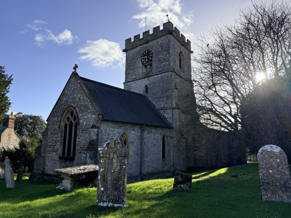
For now, turn right into the village of Wayford, passing first the parish church of St Michael and All Angels and then Wayford Manor. The church, which dates largely from the 13th century, reflects the long history of this quiet hillside village overlooking the Axe Valley, with features such as lancet windows and a 14th century font. Look out for small details, including marks by the doorway traditionally said to have been made by returning Crusaders, and a historic scratch dial in the porch, once used to indicate service times before clocks were common.
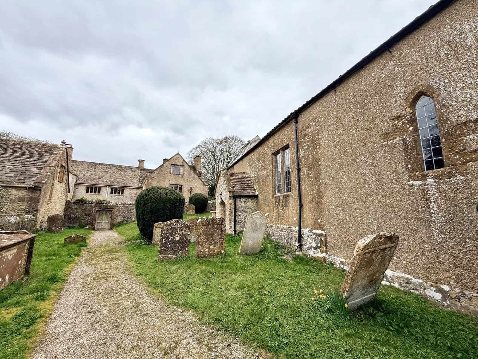
Just beyond, Wayford Manor is a striking Tudor house dating from the 16th century, built in local hamstone and later extended. The manor has long associations with prominent West Country families and forms an important part of the village’s historic setting. The house is private, but its gardens open to visitors through the National Garden Scheme, with opening dates in 2026 on Sunday, 31st May. These openings provide a rare opportunity to explore the formal terraced gardens, redesigned by Harold Peto in the early 20th century, with features including yew hedges, topiary, spring-fed ponds and a wide range of seasonal planting.
There is a pleasant bench within the village where you can pause for a moment before continuing. The route then follows what becomes an unmetalled track, heading broadly west towards Wayford Woods.
You will first pass a small volunteer’s hut on your right before reaching a short flight of steps leading up towards a small ornamental lake. Beyond this, an informal car park marks the main entrance to the woods.
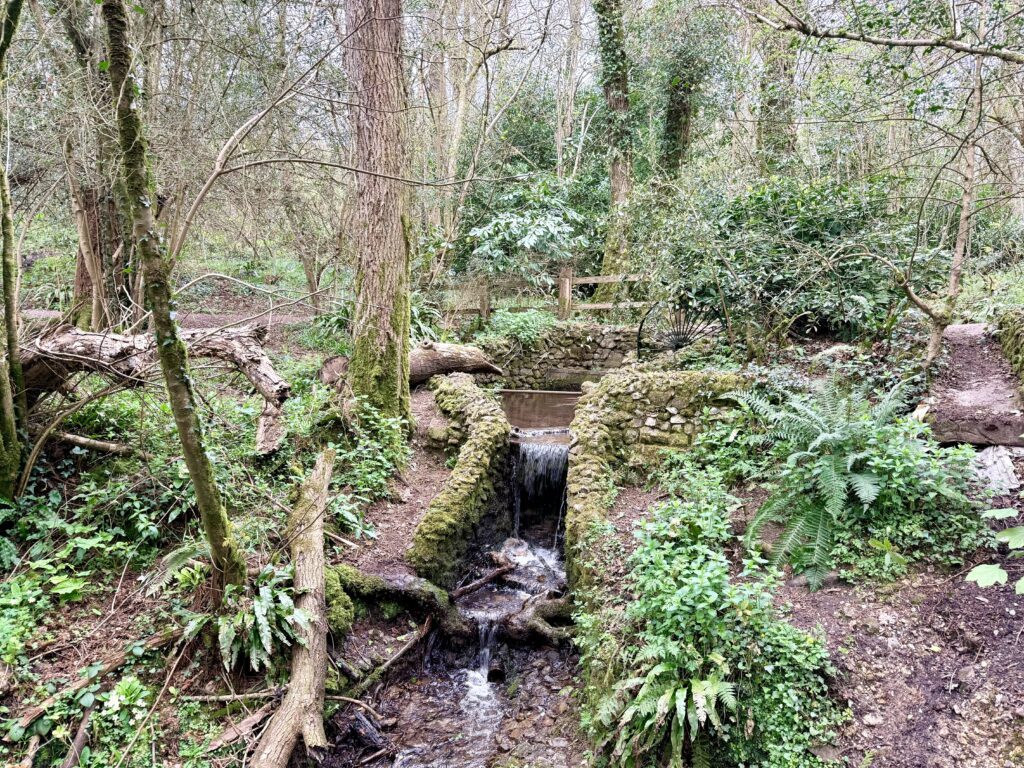
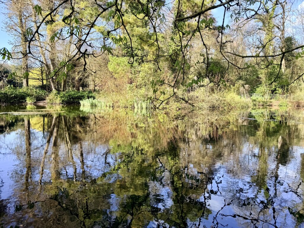
Wayford Woods
Wayford Woods is one of the highlights of this walk and well worth lingering in, or visiting in its own right. Managed by local volunteers, it is a community woodland where paths are maintained, habitats cared for and the area preserved as a quiet space for both wildlife and visitors.
The woods themselves make for a worthwhile diversion, with well-kept paths leading through a sheltered valley, across a small bridge and back again through a mix of woodland and open meadow. There is a small lake, a good chance of spotting wildlife, and several benches placed thoughtfully throughout, making it an ideal place for a short pause or picnic.
It remains a quiet corner, known mainly to locals, but popular with families, dog walkers and those who value peace, quiet and a close connection with nature. There are no formal facilities. Entry is free, but donations are encouraged to support the work of the volunteers.
If you do visit by car, please be respectful of residents in Wayford. It is a small village with one road in and out, and beyond the village the track is unmetalled and rough in places, so care is needed. A very slow approach is sensible, with an absolute maximum of 10 mph.
Although included here as part of a longer circular walk, Wayford Woods can also be reached more simply by following the Liberty Trail from Winsham and returning the same way. This makes a pleasant alternative of around 4 miles there and back, with the added benefit of easier parking in Winsham, along with the village pub and community-run shop.
6. From Wayford Woods to Winsham (7 miles)
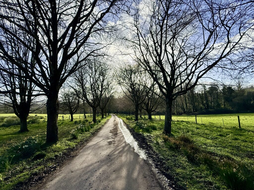
From Wayford Woods, continue along the track heading west towards Winsham and your starting point. This is a private farm track serving nearby properties, with barriers in place to prevent unauthorised vehicles.
Following part of the Liberty Trail, the route passes through attractive countryside and farmland, where you are likely to see horses, ponies, livestock and a variety of wildlife and birdlife. Just to the south runs the Waterloo to Exeter railway line, and the occasional passing train adds a small point of interest to an otherwise quiet stretch.
The return to Winsham is generally straightforward to follow. The only point to note is near Broadenham Farm, where the track turns right into Ebben Lane. While this will take you back to Winsham, the Liberty Trail and the route described here continue straight ahead through a series of field gates before re-entering the village.
This final section may be less suitable for pushchairs, particularly after wet weather. In that case, the return via Ebben Lane provides a more straightforward alternative.
Practical Information
• Parking in Winsham is limited but usually manageable with on-street options – please park considerately
• Some lanes are narrow with occasional traffic, particularly around Crewkerne Hill
• Facilities available in Winsham (pub and community shop), otherwise none along the route
• Dogs welcome but must be kept on a lead around livestock
• Footpaths and tracks can be muddy or slippery after rain
• Parts of the route use working farm tracks and quiet lanes
• Mobile signal can be variable in places
Why Walk Here?
This is a varied and rewarding Somerset countryside walk, combining quiet lanes, open farmland and woodland with far-reaching views towards Dorset. The route links together a number of highlights, including the edge of the Cricket St Thomas Estate, the historic village of Wayford and a section of the Liberty Trail.
It never feels busy, yet offers plenty of interest, from open stretches along the Chalkway to the more sheltered and peaceful setting of Wayford Woods. Along the way, there are opportunities to pause, take in the views, or extend the walk with optional diversions.
Whether you are looking for a relaxed half-day walk, a dog-friendly route, or a way to explore a quieter corner of South Somerset, this walk provides a well-balanced mix of scenery, history and accessibility.
Other Helpful Links
- Booking.com – for most accommodation needs. Look out for options that include free cancellation.
- Easy Tide – Free UK tidal prediction service, providing tidal data and tide times for the current day and 6 days into the future.
- Expedia – good for flights and packages.
- Get Your Guide – find and book things to see. Includes unusual things to do.
- Hostelworld – Hostel-focused booking platform that fosters backpack connections.
- MetOffice – Weather forecasts from the UK official meteorological office.
- National Express– UK-based coach operator providing long-distance bus services
- Omio – Book travel tickets by comparing trains, buses and planes in one search.
- Rental Cars– to search out and book hire cars.
- Rome2Rio – Great for comparing local transport options (and for locating bus stops).
- Ticketmaster – What’s On – Major Events – Venues – Bookings
- Trainline.com – our go-to online platform for booking train and bus tickets, offering route planning, price comparisons, seat reservations, and ticket sales.
- Traffic England – for live traffic updates on major roads.
- Traveline SW – Comprehensive public transport information from A to B by bus, coach, train, ferry in South West England and Great Britain.
- TripAdvisor – for reviews of… pretty much everything. Our go-to before booking anything.
- Vrbo – Great for self-catering and vacation holiday home rentals.
Over to you … have you recently travelled to South West England? What worked for you? What advice would you give to others? Please leave your comments below or join in the discussion in our Facebook Group.
New to South West England or returning after a while? Start with our ‘Travel Basics’ – quick guides packed with tips to help you plan your trip.
